11/14

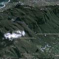
Took the photo on the right using my camera from a Huey helicopter flight, and tried to recreate the same view from Google Earth on the left. It may be easier doing this from a fixed point on land though....
- Copyright
- Creative Commons (BY-NC-SA)
- Created on
- Sunday 20 April 2008
- Posted on
- Sunday 20 April 2008
- Dimensions
- 1200*375
- File
- flickr-2427681870.jpg
- File size
- 190 KB
- Keywords
- Cape Town, GE, google earth, sea, South Africa, Table Mountain, View
- Visits
- 3115
- Rating score
- no rating
- Rate this photo
0 comments
Add a comment