2/125
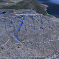
Home / Keyword Table Mountain National Park /
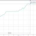
Garmin Track summary shows 12.km covered with a maximum acent of 1,177m

Screenshot
- Copyright
- Creative Commons (BY-NC-SA)
- Created on
- Sunday 16 April 2017
- Posted on
- Sunday 16 April 2017
- Dimensions
- 1002*664
- File
- flickr-33260143013.png
- File size
- 244 KB
- Albums
- Visits
- 3303
- Rating score
- no rating
- Rate this photo
0 comments
Add a comment